
what is the continental divide separates continent’s river system

continental divide
For upon |A continental divide is an area of raised terrain that separates a continent’s river systems that feed to different basins.
Loveland Continental Divide
A continental divide is a boundary that separates a continent’s river systems. Each river system feeds into a distinct ocean, bay, or sea. The Loveland Pass, pictured here, is a continental divide in Colorado that separates water flowing into the Atlantic and Pacific ocean basins.
Luncheon Pass
Drainage divides—sometimes just called divides—separate drainage basins or watersheds of all sizes. Continental divides are just drainage divides on a large, continent-wide scale. Generally, precipitation that falls on one side of the divide will flow to one basin, and precipitation that falls on the other side will flow to another basin. Shown here, the Lunghin Pass in the Swiss Alps divides water that flows toward the North Sea, Black Sea, and the Mediterranean Sea.
Great Divide
Related Posts
Every continent has at least one continental divide. Some have several because they are bordered by multiple bodies of water. For example, North America has between three and five divides. The biggest is called the Great Divide, pictured here, which runs through much of North and South America.
Continental Divide, South America
The Andes Mountains form the South American portion of the Great Divide, shown here. The divide runs from Cape Prince of Wales in western Alaska, through the Rocky Mountains of western Canada and the continental United States, then through the Sierra Madre Occidental mountains in Mexico, through Central America, and along the Andes Mountains of South America.
Lake Chad
Occasionally, water does not flow into a larger body of water. Instead, it runs toward an endorheic basin such as a saline lake or a salt flat. Endorheic basins do not connect to oceans or other large bodies of water and are usually in desert areas. Lake Chad, which is on the edge of the Sahara, is the endorheic basin pictured here. That means rivers and streams that flow into this lake do not have an outlet in any ocean.
A continental divide is a naturally occurring boundary or ridge separating a continent’s river systems. Each river system feeds into a distinct ocean basin, bay, or sea.
Continental divides are a broad, continent-wide examples of drainage divides, sometimes just called divides. Divides are boundaries that separate drainage basins or watersheds of all sizes. Drainage divides, regardless of scale, occur in raised terrain such as mountain ranges or hills.
Generally, precipitation that falls on one side of the divide will flow to one basin, and precipitation that falls on the other side will flow to another basin.
In some cases, water runs toward an endorheic basin, such as a saline lake or salt flat. Endorheic basins, which do not connect to an ocean or other large bodies of water, usually occur in desert areas. Much of the Sahara Desert in Africa, for example, is an endorheic basin. This means that rivers and streams that flow into Lake Chad, on the edge of the Sahara, have no outlet to either the Mediterranean Sea or the Atlantic or Indian Oceans.
Continental divides are found on every continent. Continents that are bordered by more than two bodies of water may have more than one continental divide. For example, North America has between three and five divides. Scientists have not yet agreed on a specific number because the exact border between ocean basins is not universally accepted.
Some continental divides span multiple continents. For example, the Continental Divide of the Americas, or the Great Divide, runs through much of North and South America. It separates the water that runs toward the Pacific Ocean from the water that runs toward the Atlantic and Arctic Oceans and the Gulf of Mexico. This divide runs from Cape Prince of Wales in western Alaska, through the Rocky Mountains of western Canada and the continental United States, then through the Sierra Madre Occidental mountains in Mexico, through Central America, and along the Andes Mountains of South America.
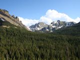
The Rocky Mountains are part of a continental divide.
Photograph by Ralph Bell, My Shot
Great Dividing Range
The Great Dividing Range is a series of mountain ranges and escarpments that runs the entire length of eastern Australia. Despite its name, the Great Dividing Range is only sometimes considered a continental divide. It separates water flowing to the Pacific Ocean from water flowing to the Southern and Indian Oceans. Australia’s interior, however, is dominated by the endorheic Lake Eyre Basin.
Comments are closed.